Anchorage – Denali – Fairbanks – Alaskan Interior
September 6 –
13, 2012
Assorted Photos From My Trip

Alaska
Flag & License Plate

My 8-Day
Excursion

Introduction
to Alaska from Fodor's Travel Guide
Alaska
is a place where northern lights color the winter sky, where the summer sun
circles the horizon, where brown bears catch salmon in wild rivers, where
Native peoples continue their centuries-old traditions, where mountaineers work
their way across glaciers, where bush pilots land floatplanes on remote
backcountry lakes, and where vast stretches of land lie undeveloped and unpeopled.
For lovers of the outdoors, few places come close to Alaska.
Alaska's
Interior remains the last frontier, even for the Last Frontier state. The
northern lights sparkle above a vast, mostly uninhabited landscape that
promises adventure for those who choose to traverse it. Come here for
wildlife-rich, pristine land and hardy locals, a rich and quirky history, goldpanning, nonstop daylight in the summer, or
ice-sculpting competitions under the northern lights in winter. Outdoor
enthusiasts can enjoy hiking, rafting, fishing, skiing, and dogsledding. And
don't forget to top off the experience with a soak in the hot springs.
Post-Trip Summary
Alaska
is God’s country. I spent 8 days in the
Alaskan Interior just before the end of the 2012 tourist season and at the peak
of fall colors. The combination of
towering snow-covered peaks, massive flowing rivers, dense forests, and clear
blue skies made for stunning photos.
Layer in intriguing history, interesting sights, friendly people, and comfortable
accommodations, and you have one memorable experience.
Where is Alaska? Alaska is located in
the northern Pacific. It borders Canada
on the east and is otherwise surrounded by water. The 50-mile wide Bering Strait separates
Alaska from Russia. Alaska is huge and
has 50% of the US coastline and is 1/5 the size of the lower 48 United States. From east to west, it stretches the distance
of Florida to California. From north to
south, it stretches from Minnesota to Texas.
One-fourth of the state lies above the Arctic Circle.
Alaska
was purchased from Russia in 1867 for $7.2 million, or about 2 cents per
acre. Russia was in a difficult financial
position and feared losing Russian America without compensation in some future
conflict, especially to the British.

How Long Was Your Trip? When
Did You Go? Where Did You Go?
My
trip took place from September 6-13, 2012, a total of 8 days. I travelled 1,100 miles by rental car,
stopping at various cities and landmarks along the way.
· I spent half a day flying back and forth from my home in Seattle
to Anchorage.
·
I spent 1-1/2 days in Anchorage touring the city.
·
I spent another 2 days traveling the Parks Highway to and
within Denali National Park, with stops in Wasila
and Talkeetna along the way.
·
spent another 2 days traveling to and within Fairbanks.
·
I spent 1 day driving over 400 miles through the remote Alaskan
Interior back to Anchorage along the Richardson and Glenn Highways.
·
I spent another half day in Anchorage before returning to
Seattle.
The
days were long and the weather generally sunny and warm, which made the
touring quite enjoyable, particularly with the brilliantly colored fall foliage.
|
Did You Do This on Your Own or with a Tour Company? I did this trip on my own, booking all air
travel, hotels, rental cars and tours on my own after doing a lot of
research. I brought a good guide book,
plenty of maps, and a good GPS.
With Whom Did You Travel? I travelled
solo on this trip. What an adventure!
How Did You Get There and Back? I flew
3-1/2 hours from Seattle to Anchorage on Alaska Airlines. The flight was 1,144 miles each way.
Where Did You Stay? I stayed in a number
of 2- and 3-star tourist class hotels in Anchorage, Healy (Denali National
Park) and Fairbanks. All of my hotels
were in the heart of town within walking distance of major tourist sites,
restaurants and entertainment.
What Was the Food Like? Go to
Alaska for seafood, which was available in abundance everywhere I went. Otherwise, you can find pretty much the same
thing as in the lower 48 United States.
How Were the People? The locals were pretty friendly. It was also like being in the Southwest US
with the large native population, in this case, Eskimos.
Was It Easy Navigating Your Way Around? Generally yes because I
had good maps. My GPS worked only part
of the time, and was useless in the desolate Interior along the 420-mile scenic
highways between Fairbanks and Anchorage.
If driving yourself, be sure to top off the gas tank at every
opportunity because you never know how far you’ll have to go before the next
filling station. I discovered several
Interior stations were out of gas, so I was driving on vapor when I finally
came to a station with gas. Prior to
that, I had not seen another car for 30-45 minutes at a time. Being low on gas in the middle of nowhere made
for a very tense situation.
What Were Prices Like? Everything was expensive, probably because Alaska
is so far from the rest of the US and remotely located.
Net-Net, What Did This Whole Trip Cost You? This was an expensive
trip on most every dimension. I spent
$2,235, or $279 per day. Airfare alone
was almost $900 for a 2,288-mile round trip flight between Seattle and
Anchorage. Lodging at $700, or $100 per
night, was cheap because I stayed in clean, comfortable, low-budget hotels in
Anchorage and near Denali National Park.
The Fairbanks hotel was expensive.
Meals at $350, or $50 per day, were quite reasonable. My sightseeing at $47 was cheap because I
guided myself, plus the $169 grand tour of Denali National Park was cancelled
due to weather, so I had to drive myself through the Park. The economy rental car at $90 for 5 days and
unlimited mileage was reasonable and gas at $4.25 per gallon was somewhat
higher than elsewhere in the US.

How was the Weather? Since I traveled
between 61 and 65 degrees north latitude in mid-September, I experienced late
fall weather. The foliage was nearly
peak colors and the days were generally sunny or mostly sunny, with daytime
temperatures in the upper 50s to lower 60s F.
It was definitely jean and sweatshirt season.
Any Parting Comments? Yes.
Travel is an adventure. It’s an opportunity to experience, learn and appreciate
how people around the world live. While I’m always happy to come home at the
end, I never come back the same person. And for that, I have a lot to be
thankful for.
Following
is a day-by-day account of my trip. Each day starts with an overview of what we
did, followed by my daily journal. You can just read on or go back to the Table of Contents above and jump to a specific day or topic of
interest. Enjoy!
Day 1 – Thursday, September 6,
2012 – Seattle to Anchorage
Anchorage
is the entry point for many Alaska visitors, who fly in to board a cruise ship
or climb into a rental car and never look back. But this city is well worth
visiting. The Alaska Native Heritage Center offers insights into the area's
earliest inhabitants, and the Alaska Zoo is the place to see animals you might
not spot in the wilderness. The Chugach State Park and Chugach National Forest
are within an hour's drive of Anchorage, so you can go hiking, fishing or
whale-watching during the day and then kick back in a brew pub or top
restaurant at night. About 296,000
people live in Anchorage.
Anchorage
isn't old enough to have a sharp identity as a city. It started as a tent camp
for workers mobilized to build the Alaska Railroad in 1915, and a few houses
and businesses went up to serve the federal employees who were building and
later running the railroad. The remote, sleepy town was enlivened by a couple
of large World War II military bases, but one writer in the 1940s thought it
still looked like the whole town had been "hacked out of the
wilderness."
People
started to take Anchorage seriously in 1957, when oil was discovered south on
the Kenai Peninsula's Swanson River. Oil fueled Anchorage's growth. Fortunes came fast and development was
haphazard. There was an explosion of residential subdivisions, for instance,
but no smaller neighborhood shopping areas within walking distance. Visitors
found a city full of life but void of charm.
In
the last 30 years, however, Anchorage has started outgrow its gawky
adolescence. It's still young, prosperous, and vibrant -- and exhausting when
the summer sun refuses to set -- and now also has some excellent restaurants, a
fine museum, a zoo, art, theater, and music.
People
still complain that Anchorage isn't really Alaska, yet the great wilderness
around the city remains intertwined with its streets. Along with a
quarter-million people, Anchorage is full of moose -- so many they're
considered pests and wintertime hazards. The urban area is home to an estimated
350 black bears and 55 brown or grizzly bears. Wildlife of all kinds
infiltrates a system of parks, greenbelts, and bike trails that brings the
woods into almost every neighborhood.
Anchorage
stands on broad, flat sediment between the Chugach Mountains and the silt-laden
waters of upper Cook Inlet. At water's edge, mud flats not yet made into land
stretch far offshore when the tide is at its low point, as much as 38 vertical
feet below high water. There's a downtown area of about 8 by 20 blocks, near
Ship Creek where it all started, but most of the city lies on long commercial
strips. Like many urban centers built since the arrival of the automobile, the
layout is not particularly conducive to any other form of transportation. But
the roads go only so far. Just beyond, the wilds beckon.
Daily Journal
Weather: Partly cloudy, 55F
I got
up at 5:20 am. I tossed and turned all night so probably only got 5 hours of
sleep. I headed to the Seattle bus at 6 am
and was at SEATAC Airport by 7:30 am and at my gate by 8:00 am. My Alaska Airlines flight departed on time at
9:00 am. It was a full flight. It was a beautiful day so I took several
pictures out the window along the way.

We
arrived in Anchorage on time 3-1/2 hours later around 11:30 am, gaining and
hour en route. Once out of the airport, I caught the city bus outside the terminal
and rode it to my hotel, the Alaska Backpacker Inn, downtown on the corner of Eagle St. and Third Avenue. It took about 30 minutes, including a short walk from the bus
stop.


I then
headed to the Alaska Experience Museum with my sightseeing map in hand. I did a
self-guided tour of the history of Alaska, the Good Friday 1964 Earthquake
Museum, shopped a few gift stores, and photographed the famous totem pole.

Then
I went to the 5th Avenue Mall for lunch. After that, I went to the Anchorage Museum to
see works of local artists and a fascinating exhibit about the indigenous
people.


In
the evening I visited a number of local bars--Bernie's Bungalow, Darwin's
Theory, and a few others. Then I stumbled home to bed.
Day 2 – Friday, September 7, 2012 – Anchorage
Daily Journal
Weather: Partly cloudy, 55F.
I
started the day with a 2-hour run and sightseeing tour. I ran a few blocks over
to the Ship Creek Viewing Platform to see if any salmon were spawning, but no.

Then I ran through an abandoned railroad yard and caught up to a train to photograph it with the mountains in the background. Then I went to the Alaska Railroad Depot for some photos and to the Eisenhower Alaska Statehood Memorial.


Then
I headed down the Tony Knowles Scenic Coastal Trail for five miles to
Earthquake Park. It was a beautiful day for a run.


After
the run, I was tired so slept. Later I walked around downtown doing some
shopping at the many gift shops.

Go to Table of Contents
Day 3 – Saturday, September 8, 2012 – Anchorage to
Denali National Park
About Talkeetna
from Fodor's Travel Guide
Talkeetna lies at the end of a spur road near Mile 99 of
the Parks Highway. The town maintains a Wild West vibe with a small, unpaved
downtown area surrounding a central green. Lucky is the traveler who gets a few
sunny days—Denali looms over the town, begging you to take dramatic photos.
Mountaineers congregate here to begin their assaults on Mt. McKinley ("Denali") in Denali
National Park; those just off the mountain are recognizable by their tanned
faces with sunglasses lines. The Denali mountain rangers have their climbing
headquarters here, as do most glacier pilots who fly climbing parties to the
mountain.
Daily Journal
Weather: Partly cloudy, 45F.
Great
weather and spectacular scenery today. I
overslept so got to the rental car agency around 9 in the morning instead of 8.

First stop was Wasila,
about 1/2 an hour north of Anchorage where I went to the Iditarod Headquarters
and Museum. This is the 4th stop along
the race route. I was greeted by a
harnessed team of dogs yelping for someone to pull in a wagon.

After
the museum, I got back on the highway and stopped by Sarah Palin's house, but
the road was closed and I trespassed as far as I could before coming to a high
fence and guard station with cameras. So
all I got was a photo looking down the drive way.

Then
I headed north up the highway another 60 miles to Talkeetna,
where I turned off the road and went 14 miles to this quaint little tourist
town with a scenic overlook offering the first glimpse of Mt. McKinley ("Denali").


Then
I drove another 120 miles to Denali National Park stopping frequently to
photograph the stunning scenery and fall colors.

I got to the hotel a little after 4 pm and 7 hours of driving. I went down the road to the 49th State Brew Pub for dinner, then drove down the road to the park entrance to scout it out and take pictures. Then it was home and to bed.
Day 4 – Sunday, September 9, 2012 –
Denali National Park
Itinerary: A day in Denali National Park.
About Denali National Park
from Fodor's Travel Guide
Denali
National Park and Preserve is Alaska's most-visited attraction for a reason:
the most accessible of Alaska's national parks and one of only three connected
to the state's highway system, the 6-million-acre wilderness offers views of
mountains so big they seem like a wall on the horizon; endless wildlife, from
cinnamon-color Toklat grizzlies to herds of caribou, to moose with antlers the
size of coffee tables; glaciers with forests growing on them; autumn tundra the
color of a kid's breakfast cereal. Denali is a chance for a visitor to have the
wildlife and scenic experience that Yellowstone offered 50 years ago, but
Denali has ever so much more as well.
Daily Journal
Weather: Partly sunny, 45F
Due
to snow overnight, the road into the park was closed at mile 3. I waited inside
with a few hundred other people until they determined whether the bus tours
could go on.


Eventually I got my money back and ventured into the park on my own, stopping at the visitor center and railroad station. The sun peaked out now and then and combined with the fall colors made for some nice photos.

Eventually,
I returned to the Wilderness Access Center and learned that the road was open. I
drove 15 miles into the Park to the Savage River area. The mountains were
somewhat shrouded in clouds but the snow cover and fall colors were worthy of
numerous photos. I especially like the tall rail road bridge with the mountains
behind it and the yellow leaves all around.

I
then went back to town and had lunch and the 49th State Pub to watch the
Packers-49ers game. The sun was shining brightly again and I rushed back to
Savage River to retake my photos. Nice. Then it was back to the 49th State for
dinner and then back to the hotel.


On the way back to the hotel, I photographed
Otto Lake. It looked like a painting
with the placid water, snowcapped peaks, fir trees and yellow fall colors.

Day 5 – Monday, September 10, 2012 –
Denali National Park to Fairbanks
Itinerary: 120 mile drive to Fairbanks and sightseeing in Fairbanks.
About Fairbanks from Fodor's Travel Guide
At
first glance Fairbanks appears to be little more than a sprawling
conglomeration of strip malls, chain stores, and other evidence of suburbia.
But look beyond the obvious in the Interior's biggest town and you'll discover
why thousands insist that this is the best place to live in Alaska. About 32,000 people live in Fairbanks.
The
hardy Alaskans who refuse to leave during the cold and dark winters share a
strong camaraderie. To live here, you really have to want to live here, which
gives the whole city a relaxed, happy vibe. The fight to stave off cabin fever
leads to creative festivals, from winter solstice celebrations to an outhouse
and snow machine tug-of-war during Chatanika Days in Chatanika, 28 mi north of town. And isn't there something
marvelous about people who, if their car breaks down and it's cold enough to
freeze the tires and make them explode, still know what to do?
Many
of the old homes and commercial buildings trace their history to the city's
early days, especially in the downtown area, with its narrow, winding streets
following the contours of the Chena River. Even if each year brings more chain
stores, the beautiful hillsides and river valleys remain. And of course there
is Fairbanks' fall/winter/spring bonus: being able to see the aurora, or
northern lights, an average of 243 nights a year.
These
magic lights were a common sight to the Native Alaskans who lived and traveled
through Interior Alaska for thousands of years. But people started coming to
Fairbanks for the view all because of one guy's bad day: In 1901 E.T. Barnette, a merchant traveling upstream, was forced to
leave the boat with all of his trading goods at a wooded spot in the middle of
nowhere along the Chena River because the water was too shallow to pass. But
while awaiting passage farther east, Barnette's luck
took a turn for the wonderful when an Italian prospector discovered gold 12 mi
north of Barnette's settlement the next summer. The
resulting gold rush created customers for his stockpile of goods and led to the
birth of Fairbanks, which for a brief time became the largest and wealthiest
settlement in Alaska.
The
city's nickname, the Golden Heart, reflects Fairbanks's gold-rush history and
its location: it's the gateway to the Far North—the Arctic and the Bering
Coast—and to Canada's Yukon Territory.
As
you walk the streets of Fairbanks today, it takes a good imagination to
envision the rough-and-tumble gold-mining camp that first took shape along the
Chena River in the early 1900s. Although a few older neighborhoods have
weathered log cabins, the rest is a Western hodgepodge that reflects the urge
to build whatever one wants, wherever one wants—a trait that has long been a
community standard (and sometimes leads to really interesting roof angles as
the house sinks in permafrost).
The
city is making some real efforts to preserve what's left of its gold-rush past,
most notably in the 44-acre Pioneer Park, where dozens of cabins and many other
relics were moved out of the path of progress. Downtown Fairbanks began to
deteriorate in the 1970s, before and after the boom associated with the
building of the Trans-Alaska Pipeline. But the downward spiral ended long ago
and most of downtown has been rebuilt.
Daily Journal
Weather: Partly sunny, 45F.
Gorgeous
drive up to Fairbanks. The fall colors
were beautiful. I stopped in the town of Nenana along the way for photos and several other scenic
overlooks. I saw two moose cross the
road, a Fish Creek sign, and Skinny Dick's Halfway Inn.


I
arrived in Fairbanks early so went ahead to North Pole on the east side of town
to sightsee. It's always Christmas in
North Pole. I stopped at the world famous
Santa Claus House. It played Christmas
music of course and had everything Christmas.

Then
I drove back to Fairbanks, checked into my hotel and went on a walking tour of
town.


I also stopped at the Visitor Center, which was highly entertaining.


Took
several photos of the downtown, then went for a 10-mile run out to the
University of Alaska.


Then
I went to a local bar filled with every derelict in town. Everyone was smoking and it was totally
vile. Later I had dinner at a local Thai
restaurant called Bahn Thai for dinner and then off
to bed.

Day 6 – Tuesday, September 11, 2012 – Fairbanks
Itinerary: Tour of
Gold Dredge #8 and the Alaskan Pipeline.
Daily Journal
Weather: Partly sunny, 45F.
I
drove up to Fox 10 miles north of Fairbanks for a tour of an old gold dredge,
with a stop at a scenic overlook and the 800-mile Trans-Alaskan Pipeline along
the way. The pipeline was right along
the road side on the way. Half of it is
underground. The above-ground portion
can't be buried because it would melt the permafrost. The caribou don't like passing under the
above-ground portion and tend to walk along the pipeline. The moose pass under it though.

After
the pipeline, I drove to Gold Dredge #8.
The pipeline ran through the property so I took some photos and walked
around until the tour started. Just
before the tour, a number of tour buses rolled in and filled up the little
train that drove us down to the dredge.
We got an explanation of the pipeline first. It was completed after a few years in 1977
and supplies 90 percent of state revenue.
At the start, 2 million barrels a day were pumped through a dozen
pumping stations along the 800-mile long pipeline. Today only 600,000 barrels a day. The train made several stops to demonstrate the
process for blasting, crushing and gathering gold-laden rocks from the
area. Giant mountains were leveled over
the years. Gold Dredge #8 operated till
1959 when the mining company ran out of profit.
Because the United States is on the gold standard its only customer was
the US government. Over the years the
price was fixed at 35 dollars an ounce.
However the cost of producing the gold eventually exceeded $35 dollars
per ounce and the mine closed. At the
conclusion of the tour we were able to walk through the gold dredge, which was
nothing more than a giant boat that gobbled up rock in front, separated out the
gold inside, and spit out the slag in back.
We also learned how to pan for gold.
We were each given a sack of rock and panned away the rock and sand in a
trough and were able to keep what we found.
The 14 shards of gold in my pan was worth $24 dollars.


After
the tour I went back to town and shopped downtown and stopped for a beer, went
out to an Italian place called Gambardella’s Pasta Bella for dinner, then went
to bed. Long drive back to Anchorage
tomorrow.
Day 7 – Wednesday, September 12, 2012
– Fairbanks to Anchorage
Itinerary: 420-mile,
8-hour drive through the mountainous Alaskan Interior.
Daily Journal
Weather: Sunny, 40F.
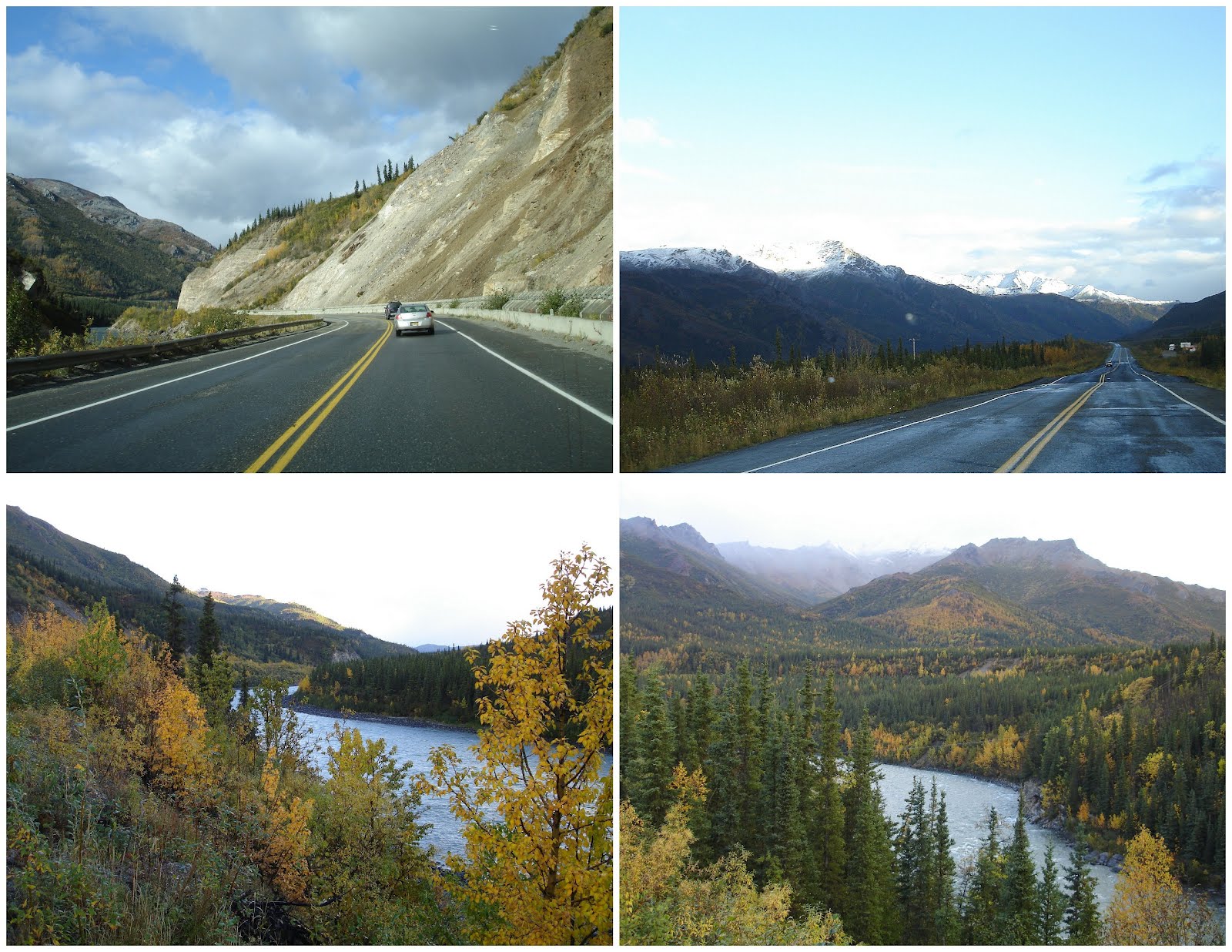
It
was a most spectacular day of driving. I left Fairbanks at 7:15 am and got back
to Anchorage at 3:15 pm, after 420 miles of driving. I could have made it
faster but I stopped often for pictures and road construction. The route took
me the long way back down the Richardson and Glenn Highways. At one point I
thought I would run out of gas because the station in Paxson
was out of gas and I had a quarter tank and 84 miles to the next stop in Glenallen. Along the way I saw a wolf, fox, bald eagle and
two caribou.


Day 8 – Thursday, September 13, 2012
– Anchorage to Seattle
Itinerary: 3-1/2 hour
flight back to Seattle.
Daily Journal
Weather: Sunny, 45F.
I got
up early and did another 10-mile run down the Tony Knowles Coastal Trail. I then packed, walked to the bus stop, and
went to the airport. On my way to the bus, I took several more pictures of the murals that cover the sides of buildings all over Anchorage.


